


neuntelstein

anniston
User
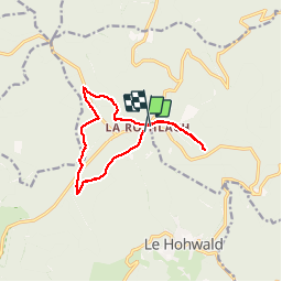

Length
10.8 km

Max alt
1044 m

Uphill gradient
223 m
Km-Effort
13.7 km

Min alt
909 m

Downhill gradient
214 m
Boucle
No
Creation date :
2019-02-17 13:14:33.375
Updated on :
2019-02-18 00:39:08.194
2h58
Difficulty : Very easy

FREE GPS app for hiking
 SityTrail
IGN / Geographical institutes
SityTrail Plus
The world is yours!
About
Trail Walking of 10.8 km to be discovered at Grand Est, Bas-Rhin, Le Hohwald. This trail is proposed by anniston.
Positioning
Country:
France
Region :
Grand Est
Department/Province :
Bas-Rhin
Municipality :
Le Hohwald
Location:
Unknown
Start:(Dec)
Start:(UTM)
375293 ; 5365154 (32U) N.
Comments